The Bullock Creek Channel and the Bridgewater Weir, Bridgewater on Loddon
I get a great deal of satisfaction in standing at the spot where a photographer has taken a historic photo. In this case the photo (above), found on the State Library website, was helpfully labelled 'Bullock Ck. Channel. Vic. (Diverting from Loddon River at Bridgewater Weir)'. This narrowed my search down somewhat. And it wasn't long before I found the very rock the photographer had rested his tripod on around about 1893. Below is how the view looks today, with the Laucke Flour Mill visible in the distance.
The Bridgewater Weir at Bridgewater on Loddon is an attractive spot, especially so on a warm summer's day. It was constructed in the 1880's. Not only did its construction make it possible for Loddon River water to run along a channel to a 'water wheel' (in actual fact a turbine) within the nearby Bridgewater Flour Mill (these days the Laucke Flour Mills) it fed water to the Bullock Creek channel which conveyed water to the parched plains of the Mount Hope Creek region in the north of the State. That area gets its water from other sources these days, notably the Waranga Basin, and the Bullock Creek channel has lapsed into disuse, unloved except by us history buffs.
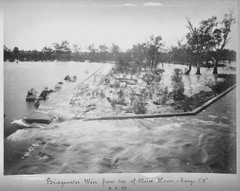
Here are two views of the Bridgewater Weir. Photo 2 (then and now) looks towards the west and Photo 3 taken from the top of the sluice house (also then and now) looks in pretty much the opposite direction. The date given for these photos is 1892.
A Google Earth view shows the locations of the above photos. The blue hatched line shows the original course of the Bullock Creek Channel.


Comments
Post a Comment