Lost Landscapes: The Creek of Weirs and Waterfalls
Main Weir, Dunstan's Flat, Faraday, Photo: Charles Nettleton ca. 1880 (State Library)
The above photo shows the lower reaches of the Expedition Pass Reservoir arm of the Coliban Channel. It gives a hint of what must have once been one of the most extraordinary creek valleys in Central Victoria, a 1600 metre stretch comprising 24 weirs, a veritable cascade of water tumbling down to meet the Forest Creek Valley, finishing with this spectacular constructed waterfall. That's one about every 60-70 metres!
At a point known in the early days as the '18 mile peg', between Porters Tunnel and Bubbs Lane, Faraday, one arm of the Coliban channel splits off to head east, skirting Mount Alexander, to eventually reach Sandhurst Reservoir, Kangaroo Flat. Prior to the construction of this reservoir, the destination of the water from Malmsbury Reservoir was the No. 7 and Crusoe Reservoirs, Big Hill. The other arm (now disused) headed more or less due north to enter Porters Tunnel near Kennedys Lane, after which it emptied into a natural watercourse that ran down to meet Forest Creek and Expedition Pass reservoir, once Castlemaine's main water supply.
The problem with using a pre-existing creek valley became glaringly obvious in 1873 when Porters Tunnel was opened to clear the debris that had accumulated inside (it had been completed in 1868). The ponded water, augmenting the natural stream flow, tore down the steep catchment, causing the rapid erosion of the stream banks, all while carrying a heavy load of silt. This sediment was carried into the newly constructed Expedition Pass reservoir and and began to quickly accumulate in its upper reaches.
Below is a 1945 aerial map with features marked, as well as a contemporary Google Earth view for comparison.
The siltation rate at Expedition Pass Reservoir was of such concern that it was decided to construct a series of weirs below Porters Tunnel to dissipate the energy of the descending water. That this was carried out was remarked on by a Bendigo Advertiser writer, 'In this gully I counted 24 weirs each 20 feet [6.1. m] wide across the stream by various depths, averaging about 10 feet [3.05 metres], and very strongly built of granite. The taking advantage of this natural channel must have made a great saving in the cost of this portion of the work, and, so far as I could ascertain, fulfilled the object in view as well as could be wished, the slopes on each side have been trimmed, and are well grassed, the reserve of ground fenced with wire and top rail, and where roads intersect, strong bridges erected, and handsome gates hung at the crossings' (Bendigo Advertiser, 20 November 1877, page 2)
Adjacent to the picturesque weir shown above, is Dunstan's Flat which was once a popular picnic spot. Some older residents of the district remember school sports days taking place here. It must have been a delightful experience, given the picnic ground's proximity to the waterfalls nearby, and two other channels which were built later, one, to provide water to the wider Harcourt district, and the other (the Golden Point channel leading to the Golden Point reservoir, built in 1913) to provide Castlemaine with cleaner drinking water as well as increased water pressure. The story of Dunstan's Flat is told by Ken McKimmie in his book 'Chewton Then and Now, Dunstan's Flat Chewton-Faraday Road', page 117 (2011). Note however, that in a marked map of the area in question, Ken labels the old Harcourt Channel as the Bendigo Main Channel, which in fact branches off some kilometres south.
But it's time to get walking to see what we can find of the original stone weirs.
Firstly, if there was channel infrastructure north of the Golden Point Road it can no longer be seen. This area is infested with blackberries and tall reeds. Any weir constructed here would almost certainly, by now, be completely covered with granitic sand. So we will begin at the first weir that's still visible, a little in from Golden Point Road. It seems to have been the most ornate of the weirs.
Here's another early view of the lower weir. As can be seen, this has been taken at a later date than the top photo as the trees were starting to grow back along the banks. A small stepped weir below the main weir is revealed in this photo. It has created a small pool which must have been a pleasant place for children to bathe in the late 19th century.
The Cascades at the top of Expedition Pass Reservoir, Golden Point Road, Golden Point.
Carter, George Levi, 1828-1923, photographer. ca. 1900
Below, is a recent view of the weir (2022). Siltation has reduced its height, floods have taken their toll and a lack of maintenance has allowed the growth of a tree Ken McKimmie has identified as a White Poplar (Populus alba), a notable riparian weed, to compromise the integrity of the weir, resulting in it being breached.
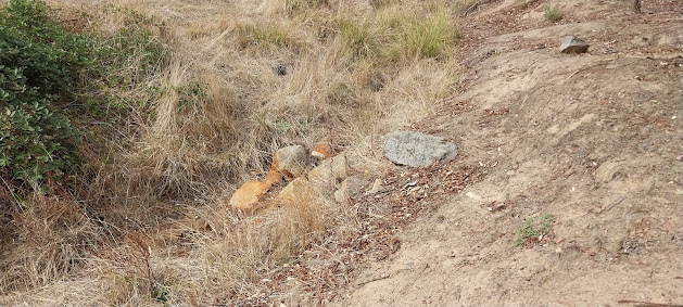
In his story on Dunstan's Flat, written prior to 2010, Ken McKimmie reports that in addition to the weir shown here, there were 4 small weirs within the main Dunstan's Flat reserve. No sign of those weirs can be seen today. These few stones may or may not indicate the site of one of those lost weirs.
To find more substantial ruins we must venture out of the Dunstan's Flat Reserve and follow the old watercourse. As I walked I tried to match the landscape to a photo which had been brought to my attention some time ago. As you can see, the photo is labelled 'The Falls, Golden Point, Castlemaine'. My feeling is that the weir shown might actually have been along Forest Creek, Golden Point. This creek, the epicentre of the gold rush of 1851, has been worked over numerous times, first by puddling and later by sluicing and dredging. Early maps show its course once ran closer to Golden Point Road than it does now, so perhaps the fence marks the boundary of this road.
Vintage hand-tinted postcard, ca. 1909 (State Library)
Nevertheless, the landscape is not unlike that bordering the Expedition Pass channel to the west. So heading south, after leaving the fenced section of Dunstan's Flat, this is the first ruined weir encountered. Is the background similar? Could the dead stump be what's left of the tree situated just above the weir in the historic photo?
A short stroll of around 70 metres leads to another ruined weir, this one close to highly eroded banks.
A short distance upstream from this weir there's one that's not nearly as intact.
And almost nothing remains of the next weir, you have to hunt carefully among the long grass next to the creek to locate a handful of cut stones.
From this point, heading up the catchment, there is a rampant growth of reeds and blackberries in the creek bed. There may well be remains of other weirs along this section but they'll remain hidden until, one day, a fire clears out the growth. Here, almost completely swallowed by blackberry canes, is another quite substantial weir.
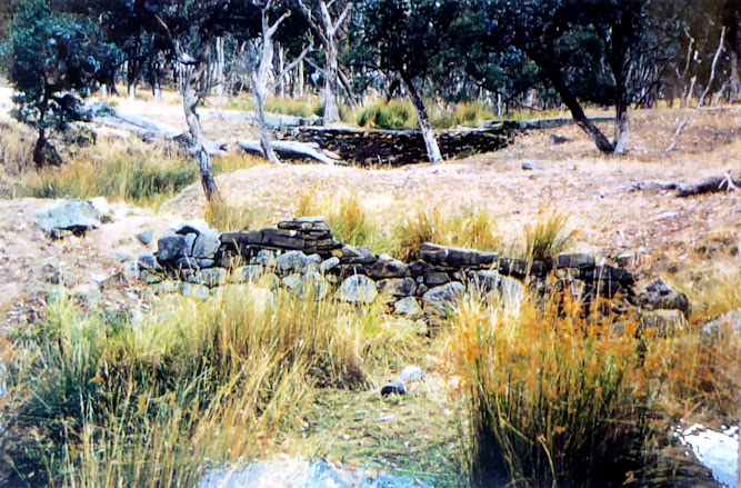
In the 1970's local Chewton identity, Elaine Appleton, photographed the next weir to be encountered. In fact you can see another weir behind it. The one in the distance has long served as a crossing point for a local farmer.
This is how that view looks today. The lower weir shows some deterioration but the dead tree lying in front of the higher weir remains there to this day.
A shovel would have come in handy to verify if various odd milled stones formed part of lost weirs or if they were remnants of stones cut at what appears to be an old granite quarry at the junction of two creeks. There's no doubt that these rocks have been quarried because of the many blast holes and cut surfaces that are still visible.
To the right (west) of the quarry you can see the prolific growth which has taken over the creek bed. There could be any number of weirs buried under that mess of vegetation. Above this quarry is a high mound of spoil most likely removed from the cutting that leads up to Porters Tunnel. The photo below has been taken from the top of this high mound.
Nearby is a flat area. It looks as if the stone masons have arranged the blocks to provide seating to make their lunch breaks more pleasant.
The creek valley now grows steeper and narrower. It's likely the remaining weirs of the 24 are along this section but again blackberry canes and reeds make it impossible to access this stretch.
Nevertheless, the odd one peeps out from under the blackberries.
A little higher up the three channel junction is reached. At this point the old Harcourt channel diverged to the east and the Golden Point channel headed off to the west. A system of sluices and gates controlled the path of the water. The photos below appear in my book 'The Coliban Main Channel : A Walking Guide' (2024). At the far left is the Golden Point Channel, mostly concrete lined. The channel snakes northwards bending west around a major stone quarry, the spoil of which is beginning to fill the channel near the Golden Point Reservoir. In the centre is the old Expedition Pass channel overflowing with blackberry canes. In the right foreground you can see the old sluice gate that regulated flow to the old Harcourt Channel. This very long channel system had a number of branches, one of which ended at gold diggings near the current Castlemaine Secondary School, as well as once providing Maldon with its water supply.
Above this junction the channel is concrete lined. When this was done in the mid 20th century, any stone weirs would have been demolished and removed. There's little doubt some of the 24 weirs would have been located in this stretch. Here are two photos, the first is how the outlet of Porters Tunnel once looked, not long after the Expedition Pass channel began to receive water from Malmsbury Reservoir in 1877, and how it looks now.
So, while quite a number of the original 24 weirs have been destroyed or lost under silt and weed growth, there are still enough remaining to provide a sense of how this remarkable creek valley might have looked in the late 19th century and early 20th century.


Comments
Post a Comment