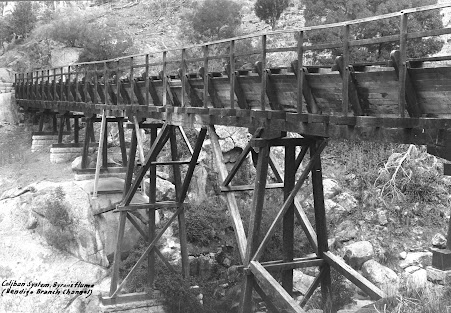
The ravine known these days as Byrnes Creek must have presented an enormous challenge for the contractor Mr Henderson and the men tasked with the job of bridging it. An early photo of the newly built flume shows how steep the ravine was. The photo below appears to be a cropped if clearer version of the one published in the book, The Coliban Main Channel: A Walking Guide (page 118). Interestingly it's labelled Byron's Flume. The landowner's surname was actually Byrnes so in the book I proffered the theory that somewhere down the line his name was either misheard or misspelt.

On page 118 there is another view of the same flume. Originally I thought that this photo had been taken earlier than the one above because (according to my theory) the handrail had yet to be installed. A closer look at the photo shows that some of the timber framing, shown in the above photo, including the handrail posts, have been repurposed to increase the capacity of the flume. This can be seen in the rebates of the handrail posts, some of which have been turned outwards and more readily reveal their history,
The gentleman standing on the flume looks very much like the same man standing on the concrete flume in the middle photo on page 129 of the book (Flume 10). If this is the case this would date the above photograph as having been taken around 1930.
Finding the exact path of the flume proved tricky. Weedy Basket Willows have completely taken over the deep gully, and an access track (requiring very many metres of fill) has been constructed, both of which have radically transformed the gully surrounds. However it was obvious in the above photos that the flume was threaded between large boulders. Surely it wouldn't be too hard to locate those boulders?
My initial guess was off the mark (the hatched yellow line). Wooden flumes aren't likely to finish at a point where they need to take a 90 degree turn. Further thought and the discovery of a photo showing both the old and new flumes co-existing gave me the clue I needed (see page 119). And yes, the boulders seen at the flume inlet in the above photos are still standing. They straddle the access track (yellow unbroken lines show original path of the old wooden flume). Arrow 5 represents the view of the top historic photo.


Comments
Post a Comment