Reading Location Clues: A forgotten camping spot "somewhere near Castlemaine"
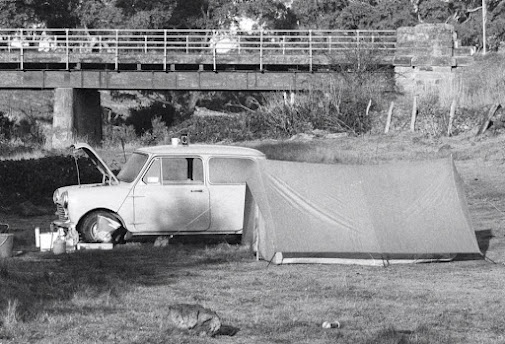
Some years back a Facebook friend posted this photo and the one below on social media. Along with these photos he asked a question: "Can anyone help us find this location? We used to go camping here in the late 1970's - on a river flat somewhere near Castlemaine. Have been looking for the past 3 years to no avail".
Surely those of us of a certain age can remember, when we were young and no doubt quite a bit less affluent, heading off on a camping holiday with the most rudimentary camping gear, just a two person tent, a small portable BBQ and a couple of fold out chairs.
There's no doubt that sometimes the simplest holidays can be the most memorable. The nostalgic charm of these photographs is almost palpable. The request sparked a chord with quite a number of people, including myself. When I first moved to Central Victoria 20 years ago I'd head to a spot not far from home to look for wildflowers and orchids. After some years of walking elsewhere at much more interesting locations I'm now unable to remember exactly where this first area was. I can picture it in my mind- alongside a straight unmade track with power lines in the distance. However, even with the aid of Google Earth I'm unable to locate it.
The request for the location of these photos in Central Victoria sparked a lot of interest among the Facebook community. People were making all kinds of wild guesses. Some guesses I could dismiss by simply looking at Google Earth and then selecting 'Street View' to see if the surroundings of the suggested bridge looked anything like these photographs.
It was a challenge I couldn't resist. So the first thing I did was to study the above photos carefully. The bridge intrigued me. These days most road bridges are made of concrete but this is a very distinctive steel bridge with stone abutments. Did it still exist? The next photo provided gave me much more to go on.
above photos courtesy Geoff Putnam
I now was able to make an educated guess of my own. Given the topography, I felt the creek had to be Larni Baramul Yaluk, once known as Jim Crow Creek. But where exactly was the campsite? I was confident I was zeroing in on the location. A cliff like the one above can be found very close to the Excelsior Bridge where the Hepburn Newstead road crosses the creek. This bridge is of historic importance. It was designed by John Monash and his partner J.T.N. Anderson and is an early example of a Monier concrete bridge. They were among the first Australian engineers to use this new construction technique but the early experiments couldn't have instilled confidence in the public. In 1901 the King's Bridge in Bendigo failed an early loading test and it's collapse ended up killing A. E. Boldt, a business associate of the owner of a traction engine which had been sent over the new bridge to test its strength.
Excelsior Bridge, Hepburn Newstead Road, Shepherds Flat
It didn't take much of an inspection to reveal to me that the creek here is too far below the road to be the one shown in the photo. And at any rate, the Excelsior bridge was built in 1909, long before the 1970's.
Soon after visiting the above bridge I was informed that the hunt was over. The camping place had been identified. In fact the bridge (Batts Bridge) turned out to be one I'd visited earlier, further north along the Hepburn Newstead road. I'd dismissed it because houses abutted the bridge at this point, one of them being a very old house built in the Victorian era. Surely my friend and his partner wouldn't have camped in the veritable backyards of these houses?
Coincidentally, another Facebook friend actually lived in the Victorian house and he revealed that his house had been relocated and repurposed sometime after the 1980's. As soon as he saw the photos on social media he had recognized the location. Not only have the houses built here closed off access to the creek, blackberries, gorse, basket willows and every weed imaginable have rendered this once delightful spot an eyesore. As for the interesting steel bridge with its historic stone abutments, it has been replaced by an extremely prosaic concrete bridge. It can barely be seen in the below photo taken in 2017.
And so while I might have missed out on the glory of being the first to answer my friend's question I had a lot of fun playing detective. And it set me off on my quest to look closely at historic photographs and attempt to read long forgotten location clues.


Comments
Post a Comment