Exploring the old Geelong Aqueduct

Geelong Water Supply Channel near Ballan ca. 1900
In the 1860's, the Irish engineer Joseph Brady was mapping out the Coliban Water Scheme, designed to provide Castlemaine and Bendigo (then Sandhurst) with a reliable source of clean water. He recognized that water from the unpolluted upper Coliban River could be harvested at a reservoir at Malmsbury and then brought to the more northerly towns via a gravity fed channel. The situation at Geelong was somewhat different. Some of the major rivers flowing towards Geelong were badly polluted. The Leigh River, a tributary of the Barwon River, flowed through settled country carrying human and mining waste from the Ballarat goldfields. Despite this, Geelong had been forced by necessity to utilise this water but the increasing focus on sanitation drove the search for an alternative supply.
After a number of false starts this search ended with the identification of the Brisbane Ranges in general, and Stony Creek, on the south western branch of Little River, in particular, as the location for a reservoir. And so in 1866, work began on the construction of the Stony Creek Reservoir, beside the Geelong Ballan Road. And, as with the construction of Malmsbury Reservoir north of the divide, poor management and design resulted in considerable delays in finishing the project. It took until 1873 for a seriously compromised reservoir to begin delivering water to the long suffering residents of Geelong. Because of the greatly reduced capacity of the damaged reservoir, a second reservoir was soon constructed lower down Stony Creek. This would become known as the Lower Stony Creek Reservoir and would boast the first concrete embankment in Australia and only the third in the world.
The full history of the Geelong Water scheme is told in Leigh Edmond's book 'Living By Water: A History of Barwon Water and its Predecessors' and is available online.

Upper Stony Reservoir with original water tower
But it's time to get walking. My aim was to explore the accessible sections of the now decommissioned 19th century aqueduct, within the Brisbane Ranges National Park. The channel originally led to a Pipe Head Reservoir at Anakie and from there, a pipeline carried the water to treatment ponds at Lovely Banks (examined earlier in my blog 'The Phantom Settling Ponds at Malmsbury').
My starting point was the original reservoir, now known as the Upper Stony Creek Reservoir, on the east side of the Geelong Ballan Road. Of the three major storages that straddle this road, only the original reservoir is open to the public. There seems to be some confusion as to the name of the picnic area and carpark here. On Google Maps the picnic area is called the Harry Peeters Reserve and yet a sign on the fence proclaims it to be the Jack Dillon Reserve. By the entrance to the carpark is the original water tower, seen in the above photo. By the looks of it, it's a tale of two halves!

Original water tower near entrance to visitor carpark
Just a heads up on this walk. It's tough. It's gruelling. It's not for the casual bushwalker who walks for mere entertainment! This is Field Rambling to the nth degree. Those who tackle it should carry plenty of water, a GPS device, a map and a compass. While you're never far from the Geelong Ballan Road (and you'll be able to tell in which direction to head to get to it from the considerable traffic noise), to locate the tunnel exits in the absence of tracks requires some inspired guesswork, a little luck, and a fair degree of help from a compass. I also advise you to carry a small spray bottle of ammonia to spray the souls of your hiking boots at intervals. Phytophthora has long been rampant in the Brisbane Ranges and on this walk you will see many instances of the dieback this fungus causes.
Here's a map of my route. There are two suggestions. The yellow hatched line is for those who can arrange a car shuttle, one car to be parked at the Upper Stony Creek Reservoir and the other at the Anakie Gorge Picnic Area. If you wish to do a return walk from the car park then I suggest you walk to the Lower Stony Creek Track, duck down to have a look at the Lower Stony Creek Reservoir, and then return via Furze Track and the Steigltz Durdidwarrah Road (red hatched line) . Whatever you decide to do, allow the best part of an entire day.

My journey began by walking towards the reservoir embankment. Here's a view of the Upper Stony Creek Reservoir from the reserve.

Before reaching the embankment (to the right of the above photo) I turned at a track which leads down to the reservoir outlet.

This track runs parallel to an old channel which I presume once carried water from the reservoirs across the road.
On the State Library website there's a historic photo (wrongly labelled as the Coliban system) of the outflow and channel just below the Stony Creek Reservoir embankment. You can see that the channel which once delivered water from the reservoirs across the Geelong Ballan Road hadn't been constructed at the time this early photo was taken (prior to 1910 when work on those other storages began). Below this photo is the same scene today.


The channel we had been following earlier is up higher on the far left. The junction of the two channels is marked by a large brick tank (out of frame). You can see that at one stage the level of the outlet channel was raised in height. Just in front of the reservoir embankment, in the distance, you might be able to see a valve wheel which was turned to open a sluice gate allowing water to flow into Stony Creek itself.

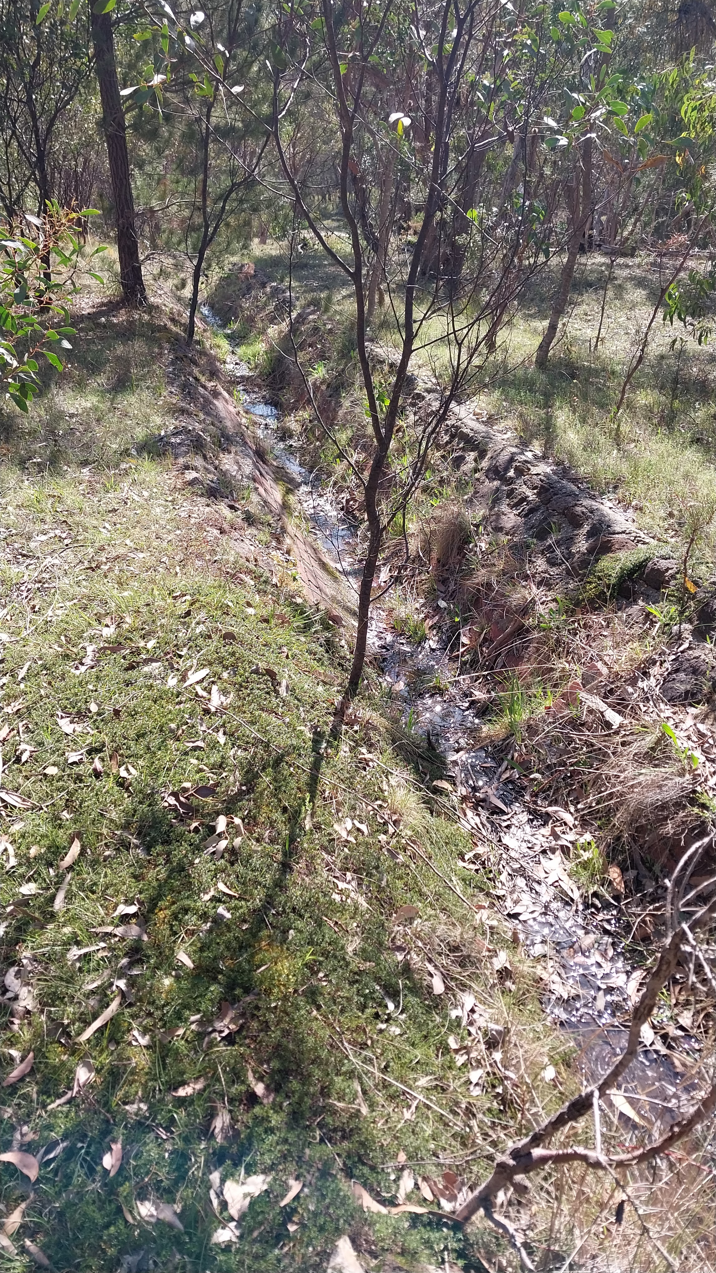
Here, the walking is easy. You'll notice that, unlike the Coliban Main Channel north of the divide, the Geelong channel is completely brick lined. A lot of brickmakers must have been kept very busy providing such a large number!

Within a very short distance you encounter a remarkable sight. An old galvanised iron flume in remarkably good condition.


The flume is very low to the ground so perhaps very little water flows in this gully. However, I would have thought that in an exceptional rain event the open flume must have ended up full of flood debris. A little further on, Beremboke Road is reached.
There's little choice but to climb over the wooden fence to continue on one's way. Soon after, I encountered the first of many metal overshoots. All are in excellent condition, if a bit rusty, perhaps a reflection that the channel has only recently been decommissioned (1990's?). These bridges are designed to channel surface water across the channel to the other side. They're often part of a catchwater drain system, whereby a parallel drain takes the worst of the debris filled surface water and dumps it on the low side of the channel.

This old gate was wide open so I passed on through.

The countryside along the channel is quite beautiful. Hopefully one day the channel will form part of the established walks within the National Park.

A little past this cutting the first of the siphons is encountered. In 1986 the old aqueduct was recognised for its historical value and the following year was classified by the National Trust. It was later added to the register of Victorian Heritage Places. This should ensure that these historical remnants remain protected.

As you can see, this gully was once spanned by a metal flume, the ruins of which are lying to the right of the photo. I'm unsure of the purpose of the excavation to the left of the siphon. Perhaps, when the siphon was being purged of sediment, the incoming water was redirected down this minor channel and allowed to flow into the gully. (The metal coils still visible in this secondary ditch have probably been placed there to prevent scouring). I wonder what happened to the flume piers or supports?


Is this a section of a siphon that predates the concrete one at this gully? Below is the a photo of the channel on the lower side of the siphon.

Within another 15 minutes of walking a second siphon is reached. The vegetation in this gully is a little denser and harder to navigate.

The buried pipe on the right hand side seems to be an earlier siphon. It's probable that a flume predated them both. After passing this point the track winds its way through a stand of young eucalypts.

And after passing one of the few overshoots made from concrete, you meet the first of many tunnels. All look very similar, unlike the variety of tunnel types along the Coliban Main Channel.

It's a shame the tunnels are of modest size and access is barred because it would save what comes next, climbing up over the ridge in an attempt to find the other end of the tunnel! On top of the intervening ridge the vegetation changes markedly. Grass trees dominate the vegetation and the signs of phytophthora are obvious. Here, before you ascend, might be a good place to give your boots a good spray.

As you can see by the pink tags on the tree, orienteers regularly run through the Brisbane Ranges. One wonders if they spray their footwear before and after they enter these areas. The vegetation on the top of the ridges is generally open and easy to walk through but finding the other end of the tunnel is quite a challenge. Generally, if you head due south, you should find yourself very close to the tunnel exit. This is where a compass, a map and a GPS device are important. Without them you might easily get lost. Remember, if you do lose your way, head towards the traffic sounds. You should come out on to the Geelong Ballan Rd which isn't far to the west, but it's not a pleasant walk back along the road verge to the Stony Creek Reservoir carpark.
And now the gruelling part of the walk confronts you. Ahead is what seems to be a never ending procession of siphons and tunnels. The gullies get deeper, the vegetation denser, the ridges higher. At this point I wouldn't blame you for turning around and going back the way you've come. The next photo gives you an idea of how rugged things get. This is the outlet of the above tunnel.

Just when you think you couldn't climb another ridge in search of a yet another tunnel outlet you find yourself staggering out on to the Lower Stony Creek Reservoir track (see above map) swearing you'll never try that again! Turn left here and follow this seldom used road down to have a look at the reservoir.

Lower Stony Creek Reservoir
Those who are returning to the Upper Stony Creek Reservoir will head back up the track to reach the Geelong Ballan Rd. There is a small carpark by the roadside here if you want to arrange a different car shuttle, but it's easy to miss it as you barrel along that road at 100 kmh.

Luckily there's a track which runs parallel to the road here. Head north and then cross the road at the signpost. Across the road is Furze Track and another carpark. Follow Furze Track all the way to the Steiglitz Durdidwarrah Road making sure you don't accidentally turn on to Pine Track or else you'll really end up taking the long road home. This is why a (fully charged!) GPS device or mobile phone walking app is so important to carry. The track is pleasant and meanders through a range of vegetation communities.

The Steiglitz Durdidwarrah Road is a bit of a slog but soon you'll pass by the No 2 Stony Creek storage basin (a veritable inland sea!) and hit the main road. Your car isn't far up the road to your left. Needless to say, considerable care needs to be taken walking along the road verge of the Geelong Ballan Road. It's certainly not designed for pedestrians.
Okay, so back to the Lower Stony Creek Reservoir. As stated earlier, the Lower Stony Creek Reservoir, now decommissioned, is an early and nationally significant example of a concrete walled dam. It was built in the very good time of 18 months and has held up well for 150 years. There are a number of historic photos of the reservoir.

Reservoir soon after construction, 1870's, Geelong Library

After your well earned break here, it's time to follow the access track down past the wall and then turn sharply left to have a look at the wall itself from below.

The scour valve open, Lower Stony Creek Reservoir, Victorian Heritage Register

The same view today

Outlet valve, Lower Stony Creek Reservoir


Anakie Pipe Head reservoir ca. 1900
And now, at last, you've reached the Anakie Gorge picnic ground and your car. I hope you've enjoyed your journey along one of the most interesting and important 19th century infrastructure projects in Victoria. Let's all come back and do it again some time!
AFTERWORD
So why does the above walk finish at the Lower Stony Creek Track even though the aqueduct continues on? I consider the final section south of the track not readily walkable. Even with stringent efforts to treat boots and shoes against spreading phytophthora, too much off track walking is required. In addition, excellent navigation is needed because the last tunnel is extremely long and difficult to follow aboveground. The aqueduct finishes in what appears to be now freehold land, or, at least, land that has been leased for grazing.
Nevertheless for those curious, the route of the aqueduct is marked in blue on the map above. I will detail my own adventure making sure to stress that I'm not encouraging anyone to replicate my path. Before the super long tunnel is reached there are two tunnels of the type encountered in the previous section.

There's also a steep siphon in a very rugged deep ravine to negotiate. Thankfully, aqueduct access tracks, albeit rather overgrown these days, guided me along the way. Sometimes I came across walking tracks upon which cairns of rocks had been placed to let me know I was heading in the right direction.
Up to now I'd been heading generally south but after the third tunnel in this section the aqueduct suddenly turns east-southeast. Luckily the access tracks generally follow the underground path of the tunnel. And I could tell I was on the right track because along it there are regular horseshoe shaped spoil mounds, perhaps of material excavated from the tunnel.
The first proper track encountered is the Ted Errey Nature Circuit which led on to Redbeak Track. At Switch Road I turned left and then right on to the appropriately named Aqueduct Track (because the tunnel is close by below). When this track turned to the left I followed a rather overgrown access track straight ahead. This led, finally, to the outlet of the last tunnel on the system. It appears some keen speleologist has removed the grate. Did I contemplate entering this low dank tunnel? Not on your life!

And then the aqueduct disappears! Or, at least, at first it seems that way. The water once tumbled down a flight of rock steps to enter a natural watercourse. What a sight it must have been in the days the aqueduct was running to see the stream flowing rapidly down the gully. At intervals the stream is directed into stone chutes.

Along some sections corrugated iron confines the flowing water to the deepest part of the stream bed.

The stone structure you see here is, what's called in the trade, a gradient check. In the 19th century they were simply called "drops". They're designed to protect the bed from scouring due to water turbulence. There are many impressive gradient checks along the creek bed.

Sometimes the creek looks completely natural and not part of some highly sophisticated water transport scheme at all!

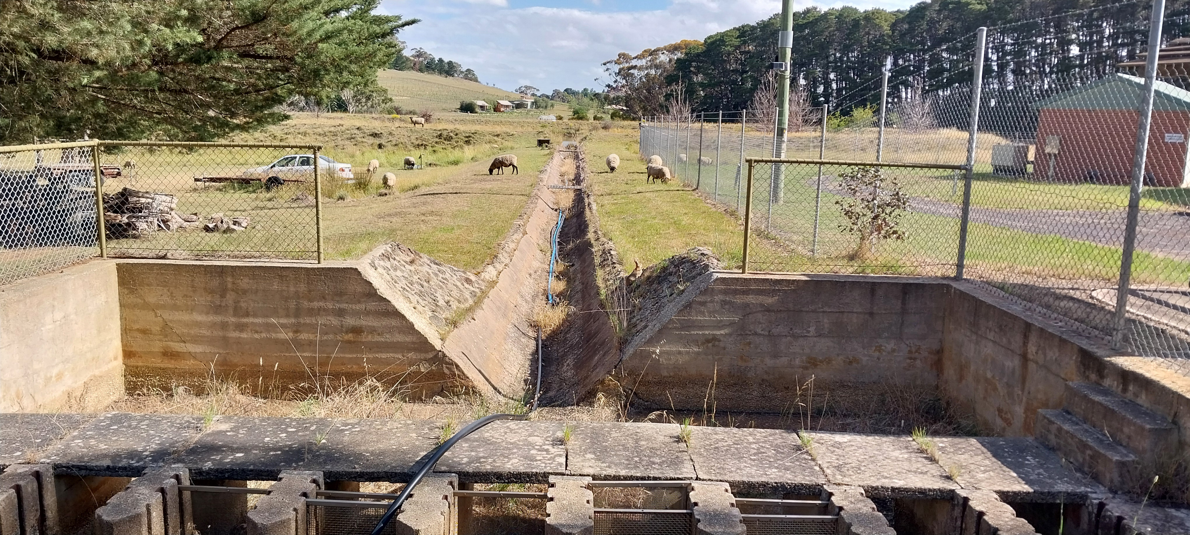
As you can see, there's quite an established track along the channel at this point, which showed me I was on a well worn path. But at last civilisation was reached. A brick sluice once regulated the water flow into the original Anakie Pipe Head reservoir, now apparently used for recreational purposes by nearby residents.

Below the Pipe Head reservoir is the round raised holding basin mentioned earlier. A channel leads from the reservoir to the holding basin. Note the rabbit on the right side of the channel, as well as the flock of sheep allowed to graze on the banks of the basin.
It's unclear if this land is now privately owned. Approaching from the west there are no signs indicating that access is prohibited but to reach Staughton Vale Rd there was no choice but to walk out along the driveway. I certainly wouldn't have looked forward to returning the way I came. For this reason I wouldn't recommend following in my footsteps.
Hopefully one day an established walking track will be created along the old aqueduct. It would surely be quickly recognized as one of the most interesting in Central Victoria.


Comments
Post a Comment