The Lost World of Survey Markers and Stone Cairns
My adventure exploring the Heathcote Water Trust Channel gave me a thirst that I thought I'd slake at the Tooborac Hotel, Tooborac. However no sooner had I walked in than I spied the above photo high on the wall of the hotel's dining room. The plaque at the bottom states that it's a photo of the 'Major Mitchell Cairn, ...On 'Flagstaff', Erected 1836'. So here was a challenge I couldn't resist. Where was this 'Flagstaff '? Does the stone cairn still exist? And was this cairn associated with Major Mitchell and erected in 1836? The photograph appeared to have been taken sometime in the early 1920's.
First step, as usual, was to conduct a search on Trove and the State Library website. I knew from past experience, (refer to a previous blog: The Survey Marker Hidden in Samuel Calvert's View of Mount Alexander, 1862) that flagstaffs were regularly erected on the very tops of hills and mountains to aid early surveyors. Generally they consisted of a cairn of rocks in which a flagstaff had been inserted. As it was the visibility of the flagpole itself that was most important to the land surveyors, a flag flying from it wasn't needed.
Given that the photo is in the Tooborac Hotel, it seemed reasonable to conclude that the flagstaff or survey marker was in the Tooborac area. And this seemed borne out by this charming letter published in The Advocate, a Melbourne newspaper that was published up until 1954. Like a number of newspapers it had a page for children, in this case, a Children's Corner and a Letters page, where children could direct their observations and musings to Aunt Patsy. I remember from my own youth, The Melbourne Sun News Pictorial and The Sun Children's 'Corner with Corinella' in which young Sunbeamers were encouraged to write in offering jokes and puzzles for which the sender might earn a certificate. Here's a letter from eight year old Nellie McHugh, published in The Advocate, July 13, 1912, page 44.
So the Flagstaff was on 'one of the highest hills' in Tooborac. A good place to head to first seemed to be Mount Tooborac which overlooks the town from the east. Luckily the peak is within the Tooborac Bushland reserve accessible via Paddys Dam Rd. It's a tough climb but at the top is a cleared area. And here I was relieved to find the old cairn still surviving.
As you can see, the large coffin shaped rock is quite distinctive in both the historic photo and the photo I took.
The next question to be answered was the cairn's purported connection to Major Mitchell. Well, we know that Mitchell never passed through Tooborac. His expedition passed through Mia Mia, Argyle, Costerfield and from there on to the Nagambie area. Close but no cigar. At any rate it's highly doubtful the expedition would have had time to erect such a massive stone cairn. They were men on a mission and, more likely than not, would have left the fine detail to the surveyors that came later.
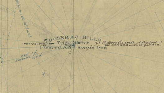
However, in this case we know there was no stone cairn on Mt Tooborac prior to 1856 because it would have been marked on an important surveyors map, A 'Trigonometrical Survey of Hills in and around the Heathcote District, 1856'. Below is a section from the map. Note that although Mt Tooborac was an important Trig point, as can be seen by the multiple radiating survey markings on the map, at that time it consisted of a cleared hill and one lone tree. This seemed to be the early default for surveyors, clear the hilltop while leaving a single tree, which it was hoped would be visible for kilometres.Obviously at some stage it was decided to erect a stone cairn and flagstaff on the summit to serve as a Trig Point. Perhaps the tree collapsed or was destroyed by fire? The wider map shows that, already by this time, stone cairns had been erected on the top of other notable hills.
Nowadays Trig Points exist in the ether, within the world of GPS co-ordinates. Hopefully, these quaint mementos of older surveying methods will continue to survive, protected by stringent heritage orders.


Comments
Post a Comment