E. E. Bassett's Tunnel Hill Market Gardens

Bassett Family Collection, Circa 1930 Tunnel Hill (Peter Bassett)
Most of my adventures start with encountering a historic photo I haven't seen before. The above photo was posted on social media, along with the following request: 'Would someone recognise where this might be? This is a photocopy that we found when we bought our property on the corner of McCay Reservoir Rd and Pyrenees Highway, Chewton. There's a small cottage in the background of the photo and we can't work out where it may have been or from what angle the photo would have been taken'.
I find it very hard to resist such a plea. This shouldn't be too hard I thought. I quickly worked out that the hill in the background must be Tunnel Hill, so called because the Elphinstone railway tunnel burrows through the northern flank of the hill. These days a Fire tower is perched on top of it. The road visible on the far right is then almost certainly the Pyrenees Hwy which has had a number of names over the years, even being called the Calder Hwy at one stage. So the photographer is looking pretty much due east.
A few of the older members of the social media group helped me narrow my search down and I quickly found confirmation in a relevant allotments map downloaded from the State Library maps section. Here is an excerpt of the map showing E. E. Bassett's property coloured in red. The location is on the boundary of Chewton and Tunnel Hill. The E. E. Bassett shown here was Ernest Edgar Bassett (1865-1939). His son Edgar (Ernest) Bassett continued growing vegetables on these gardens after his father's death.

The purchase dates for the blocks in red are all within the first 10 years of the 20th century. It seems there were a series of small allotments straddling Wattle Creek within E. E. Bassett's property bordering the Melbourne Road. Perhaps these blocks predated his purchase of the wider property. But there was now no doubt the above photo was of the owners' own land. All we needed to do was find the place the photographer stood and the location of the cottage visible in the historic photo.
Below is an aerial map from 1963. The market gardens are hard to see, but the outline of one area of market gardens can be seen on the left, abutting Wattle Creek, the light coloured border faintly visible. Notice that Wattle Creek has been rerouted closer to the road compared to the Allotments map. This has left a fertile area of a rich dark colour between the old course and the new course which undoubtedly must have been the location of the market gardens.

Once I had alerted the owners that I now thought I could provide answers to their questions, they kindly invited me to inspect their property. The property is resplendent with historical remnants and I hoped to be able to explain what I thought they were. First we inspected the stone footings of the cottage in the top photo. The owners appeared not to have made the connection between these footings and the cottage in the photo. I then showed them where I thought the photographer stood for the top photo.

Those pesky trees made it hard get a good comparison shot but below is what I think the angle of view is in the top photo. The light coloured rectangle just a little below and to the left of the large dam is where the cottage was located. So if the photo dates from around 1930 we can say it was demolished between that year and 1946 as it doesn't appear in a 1946 aerial photo.

Here's a closeup of the footings of the cottage observable in the top photo.

So let's look at the early history of this property. The Allotments map shows that E. E. Bassett assembled his holdings over two or three years, buying them as they came up for sale. I believe that the first bought, the most westerly, was near the location of the vegetable garden in the top photo. He seems to have started raising vegetables in the late 19th century. In 1911, the Bacchus Marsh Express (Sat Dec 9, page 3) reported that he'd put in 5000 cabbage plants before the beginning of winter and was now selling them for 6d (pence) retail. The reporter implies that E. E. Bassett was making use of cheap irrigation water from the Coliban channel (taking water from the Poverty Gully race which runs along the eastern border of the property) and expresses surprise that other land owners near the channel weren't making more use of the water.
Here's a 2017 Google Earth photo of portion of the property. In some years, or when the light is right, the old market garden furrows reveal themselves.

There's certainly no doubt Coliban water was being used on the market gardens at some stage. Peter Bassett, E. E. Bassett's great grandson writes that in the 1950's water was being pumped from the Railway Dam across the Pyrenees Hwy. This dam originally supplied steam trains with water. Perhaps it was cheaper to bring water from this dam than to pay for Coliban water delivered by the Poverty Gully Race. An old ditch which once carried water from the Poverty Gully Race snakes across the property and can still be seen today.

Old channel leading from Poverty Gully Race
The owners, Christina, Alan and I then walked along the now discontinued channel noting the old offtake to E. E. Bassett's property. The size of the hole in the concrete wall dictates the size of the water allocation. Still visible along the Poverty Gully race elsewhere are timber channel offtakes with a small hole which only allows a proportionally low flow rate.


In the late 1950's the McCay Reservoir was constructed, with the Poverty Gully Race decommissioned about 10 years ago. Public access is restricted at McCay Reservoir. Some years ago I was given permission to enter the reservoir. It's a very pretty body of water.

McCay Reservoir
Here's a section of the Poverty Gully race, a little to the northeast of the property once owned by E. E. Bassett.

Poverty Gully Race, south of McCay Reservoir, north of Pyrenees Hwy
Closer to the Siphon it seems that perhaps someone whose name started with N has carved their initial into the stone sides. Also, pick marks on a rock can be seen towards the right hand side of the photo.

This section of the channel leads to a siphon inlet which takes water under the Pyrenees Hwy and the railway line to surface within the Fryers Ranges State Forest.

Interestingly, a Star of David has been inscribed into the concrete here, perhaps a sign of the religion of one of the workers? The symbol could also have a Masonic connection.
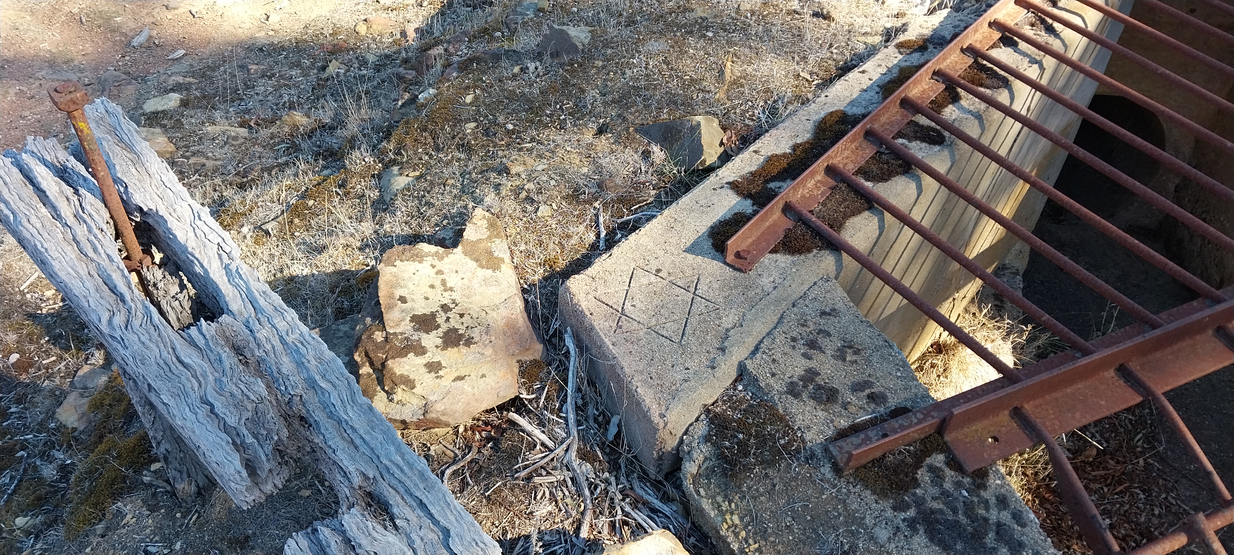
Also of interest is the special rake left here, presumably once used to free branches stuck in the grating.

The siphon pipeline can easily be seen heading down the hill.

Alan and Christina (seen above) are very lucky to own a property with such a rich history. Everywhere you look there are reminders of the 19th and early 20th century. Not far from the siphon inlet there are the ruins of a brick cottage. It looks to have been very small but nonetheless might well have been the house of an early channel keeper. It was their job to maintain a stretch of the water race and it makes sense that they would have lived somewhere between Coopers Tunnel to the west and the Poverty Gully siphon. We'll probably never know the answer but the bricks look to date from around 1870 which is when the channel keeper's houses were being built.

remains of brick cottage near Poverty Gully siphon
And so I was able to answer a few of the questions surrounding this wonderful property but there are still a few tantalising mysteries. What happened to the cottage in the photo? When were the market gardens sold and the land reverted to pasture? Hopefully more information will come to light.


Comments
Post a Comment