The Photos of Philip Wilkin: The Coliban Main Channel, Then and Now

This is the Coliban Channel flume (or water bridge) that once straddled both Springs Road and Emu Creek at a place called Cuneens Gully, Mandurang South. As horse and buggies, and perhaps early motor vehicles passed underneath, overhead, Coliban water was flowing on its way to Bendigo. The photo is dated to the 1920's and appears in a self published A4 folio type publication, 'Along the Channel' (2012) put together by Philip Wilkin, whose family has had a long association with this area. The book details his experiences riding a mountain bike along the channel in 2011 and contains a wealth of photos including some that appear to have been taken by members of his family in the early 20th century. It's possible these photos have, until now, only appeared in Philip's book which had an extremely limited print run. 'Along the Channel, Some of the Historical and general features along the Coliban Main Channel' can be printed on demand through the Malmsbury Historical Society.
This highlights an important issue, how best to preserve precious historical records. Many of us have had the experience of discovering that valuable historic documents and letters have ended up in landfill on the death of their owner. Families who perhaps don't have a deep interest in history often don't have the time to sort through a mountain of papers and photos left behind by a departed member of the family. And in our digital age, when phones can hold thousands of photos, what family member is prepared to scroll through those images to copy those that might be of immense value to historians in the distant future? Those phones, especially if they're older models, are likely to end up in E-waste.
The internet seems the best place for such ephemera but often elderly people haven't the skills or knowledge to know where to direct those records or how to do so. And even when, say, a Facebook group exists which is appreciative of historical material, there's no guarantee the group will last. When the administrators dissolve the group, many years of interesting records may well disappear into the ether. I don't have an answer to this problem. All we can do is preserve such records as best we can and if subsequent generations aren't interested in carrying the torch then so be it. It'll be a sad loss but there's little doubt many of us won't be around to grieve.
This brings me to my own project. One of the things that has interested me in the last few years is to download a historic photo, try to find its location and then capture how that location looks today. I endeavour to try to stand exactly where the original photographer stood but it's often impossible. These days trees almost always get in the way! Nevertheless, here are some old photos of the Coliban channel and how those locations look today, starting with the photo above. Once again I'm reminded how the landscape can be completely transformed in 100 years.

As can be seen, Basket Willows have completely taken over Emu Creek on the right hand side (north) of the photo. I think they're a scourge but I've met farmers who say they prevent erosion and provide some degree of habitat in a greatly altered landscape. The flume has been replaced by a concrete race which runs under the road quite some distance away down the road.
Here's another view of that same flume taken from the hill above the flume looking southeast (page 61). The growth of the willows makes it impossible to replicate this photo.


While scrambling up the hill after taking this photo, I accidentally dropped my credit card and two other important cards. Later that evening, when I realised I no longer had them, I had to retrace my steps in the hope of finding the cards. Luckily I'd been using a GPS tracking app earlier and so was able to retrace my steps exactly. And there they were, lying on the grassy slope just here.

Philip writes, "During the early 1930's this section of the channel (Preston Vale, between the Harcourt Sutton Grange Road and the North Harcourt Road) was concreted, this provided much needed work for some of the local men. My grandfather (Charles Wirth) also worked on this project" (page 49). The exact location of this photo was difficult to find. This seems to be the closest match. It's quite possible that the tree directly behind the group of men has survived. Besides the hill in the background, a valuable clue is those dark barked trees in the background. They're almost certainly Mealy Bundy, Eucalyptus goniocalyx and there's really only one place in Preston Vale they occur, which is where I stood to take the photo below. The difference in the size of the hill in the two photos can be explained by the difference in focal lengths between my phone camera and the original.

Here's another photo of workers on the channel. Philip writes that it's their 'smoko" and a chance to relax for awhile. Not many workers smoke during their break these days but it provided a handy excuse for a rest when smoking was much more common,

I haven't given up hope of finding the exact location of this photo but unfortunately some sections of the old channel are hidden by blackberry thickets while other sections have been replaced entirely by later built concrete races. Again, it's almost certainly at Preston Vale and my photo shows how the old superseded channel looks in that area today.

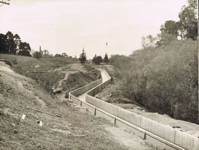
And now to other historic photos of the channel. I'd long believed that the box profile (U-shape) of the Coliban concrete races was a post WW2 invention. I was mistaken. Here's a photo of the Malmsbury viaduct, one of the Rose series, that has been dated to 1934. This is north of the viaduct looking south east.


Around the same time, in the early 1930's, another photo was taken from almost the same place but looking the opposite way (northwards).


Comments
Post a Comment